
“We’ve already seen wind gusts of above 90km/h and squally showers for the Perth metro this morning,” said the Bureau of Meteorology’s (BoM) Jonathan How.
Heavy rainfall of more than 30mm is expected over the coming days, with the front expected to extend to southern-eastern parts of the country later in the week.
Significant thunderstorms are possible along the front itself as it reaches the coast, as well as in westerly winds following the passage of the front.
The potential for damaging winds and heavy falls in showers and thunderstorms is likely to continue through Tuesday and into Wednesday, according to the BoM.
“Damaging winds above 90km/h do have the potential to cause damage to homes, property and vegetation,” How said.
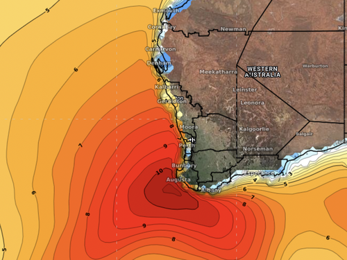
Weatherzone has warned people near the coast to expect large, powerful waves, saying the waves could potentially reach seven to 10 metres today.
The waves are expected to be particularly strong until about Thursday.
“Significant wave heights above seven metres could cause coastal erosion.”
Damaging winds will set to increase for South Australia from Tuesday morning.
By Thursday, showers are set to push into parts of inland NSW and southern Queensland.
North-east Victoria and south-east NSW on Wednesday and Thursday can expect heavy rainfall.
“Some areas could exceed 100 to potentially 200 millimetres,” How said.
“We will be issuing a flood watch for these areas, including parts of northern Tasmania.”

Sydney icon disappears under heavy blanket of fog
التعليقات